Visit Poland › History

Where regional history clarifies family origins

This is the regional history page for ancestry research. Use it when your trail runs into older borders, renamed towns, partition-era records, or regional identities that change where church books, civil records, and archive holdings may now live.

How regional history helps ancestry research

The point is not to memorize every era. It is to understand which political border, church structure, archive network, and local identity shaped the place your family came from.

Before 1918

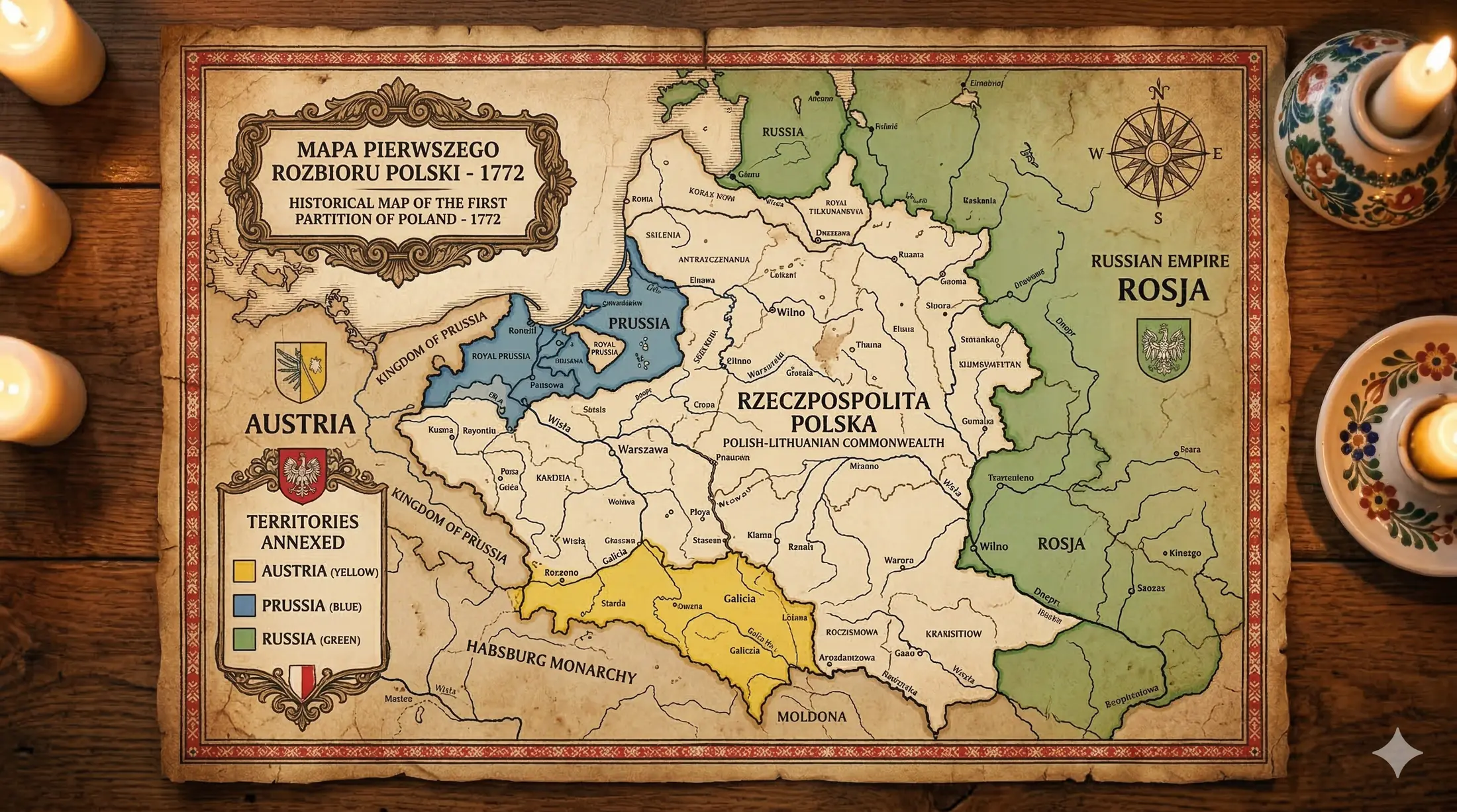
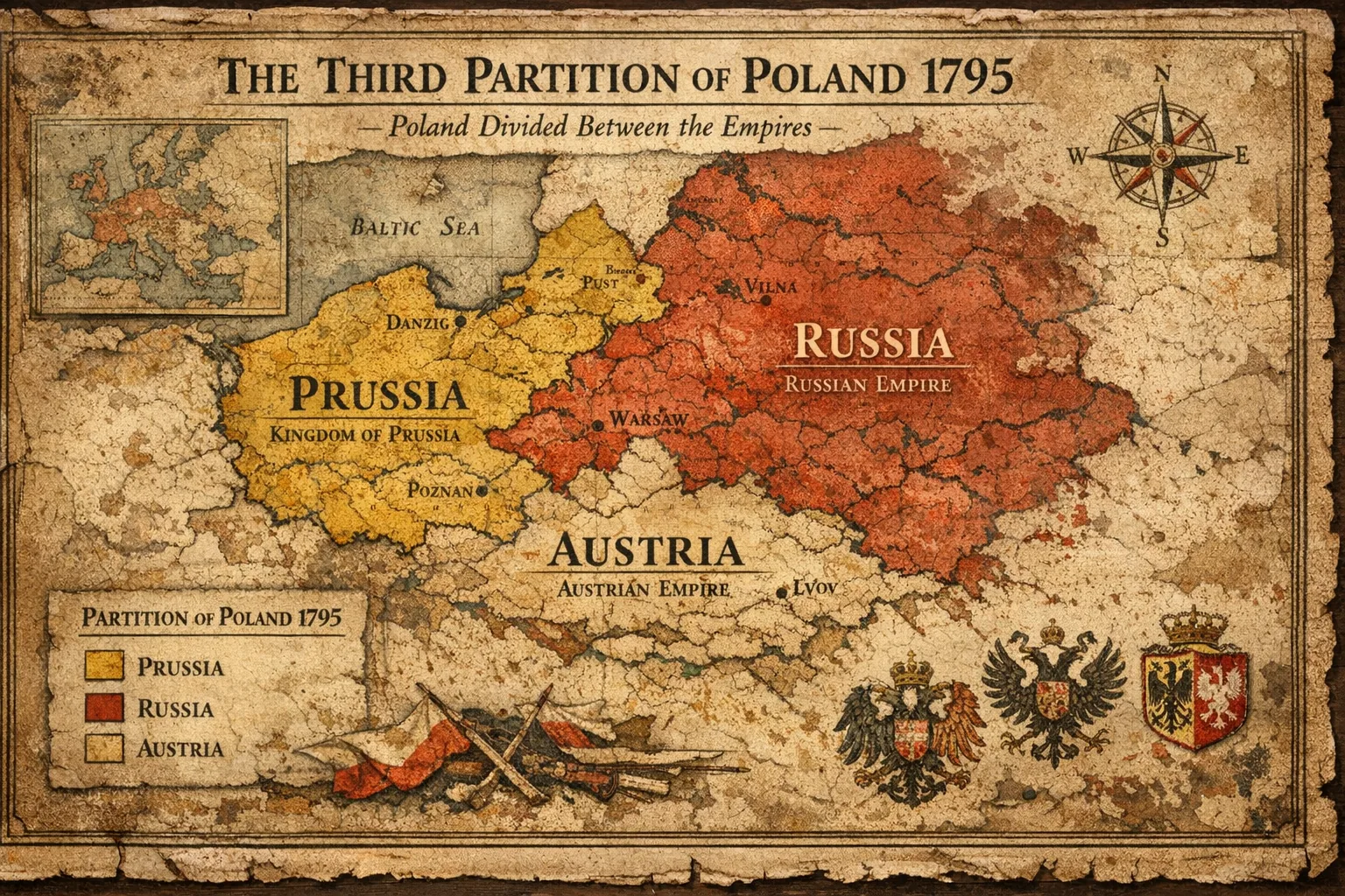
There was no independent Polish state after 1795

After the third partition in 1795, Poland disappeared from the political map. If your ancestors lived in Polish lands before November 11, 1918, they were usually recorded under Russian, Prussian, Austrian, or local church administration rather than under a Polish national state.

  • That is why a family may say “from Poland” even when the original record was created in the Russian Empire, Prussia, or Austria-Hungary.
  • It also explains why surnames, place names, and even alphabets may differ across generations.
1918 to 1939

Poland returned in 1918, but the borders settled over several years

Poland re-emerged as a state in November 1918, but the borders were shaped through wars, uprisings, and treaties through the early 1920s. The Treaty of Riga in 1921 helped define the eastern frontier, and some boundaries were internationally confirmed in 1923.

  • A town recorded as Austrian or Russian in an older record may appear in interwar documents simply as Poland.
  • If your proof chain crosses 1918, the same family may appear under two completely different political systems.
1939 to 1945 and after

World War II and 1945 shifted Poland west

After the German and Soviet invasions in 1939, Poland was broken apart again. After 1945, Poland's borders moved west: eastern lands were absorbed into the Soviet republics of Lithuania, Belarus, and Ukraine, while former German territories in the west and north became part of postwar Poland.

  • If the family place was once in eastern Poland, the records may now be outside modern Poland, so start with the borderland parishes and expect the archive trail to extend beyond today's Polish border.
  • If the family place is in modern Wrocław, Szczecin, or Olsztyn, older records may be German rather than Polish, so compare the Prussian and German parishes before assuming the locality has no Polish-facing record trail.
Research shortcut: before assuming a record was lost, ask three questions first: what state controlled the town when the record was created, what church or civil system governed it then, and whether the town still sits in modern Poland today.
Interview relevance

These history basics are also practical interview material. Questions about Poland's partitions, independence, major border shifts, and regional identity come up frequently in Karta Polaka interviews when the consul wants to see whether your connection is real and informed.

The interview is in Polish, so this matters even more if you do not already speak comfortably. Web Study Access gives you this history material in Polish so you can practice the actual wording, while Android App Access is the lighter native practice path for repeating likely history and culture prompts over time.

Border changes and time frames that affect records

These are the main turning points that change where records were created, what language they may use, and which archive system may hold them now.

1772, 1793, 1795

The three partitions erased the Polish-Lithuanian Commonwealth. Lands were divided among Russia, Prussia, and Austria, which is why pre-1918 family records often point to one of those empires instead of “Poland.”

1815

The Congress of Vienna reshaped the map again. Congress Poland was linked to the Russian Empire, Prussia kept western areas, and Austrian Galicia remained in the south. This matters because nineteenth-century record systems diverged sharply after this point.

1918 to 1923

Independent Poland returned, but the borders stabilized gradually through conflict and treaties. Interwar records may be easier to find under Polish administration even when earlier family documents were created under partition authorities.

1939 to 1945

The war destroyed institutions, displaced communities, and redrew borders. After 1945, Poland shifted west, which is why some “Polish” family places are now in Lithuania, Belarus, or Ukraine, while some modern Polish cities have earlier German records.

Map of the first partition of Poland in 1772
First partition reference

This map helps explain why an ancestral town can feel culturally Polish while still entering the record trail under a foreign imperial system.

Map of the final partition of Poland in 1795
Poland removed from the map

By 1795 there was no independent Polish state, which is the key background for many pre-1918 birth, marriage, church, and civil records.

Gdańsk shipyard scene tied to the Solidarity period
Twentieth-century rupture

Later upheaval matters too: war, displacement, and modern state rebuilding are part of why family memory and paperwork can point in different directions.

Historic center of Kraków
Galicia and royal south

Kraków helps anchor the southern story: old Galicia, royal memory, and the part of Poland where many church-book trails stay deeply tied to local parish structures.

Old Town in Warsaw
Central Poland and state return

Warsaw is the clearest symbol of rupture, rebuilding, and the restored Polish state, which matters when family records cross from partition rule into interwar Poland.

Historic waterfront in Gdańsk
Prussian and Baltic context

Gdańsk and the Baltic north help explain why western and northern research often runs through German place names, mixed-language records, and different administrative habits.

What the main historical regions usually mean for research

These are not perfect legal definitions, but they are the practical regional buckets that most often explain record language, archive logic, and where to keep searching.

Austrian Galicia

Southern Poland: Kraków, Tarnów, Rzeszów, Przemyśl

Galicia belonged to Austria from the late eighteenth century until 1918. This is one reason families from Lesser Poland and parts of the southeast may surface in Austrian administrative structures even when they always thought of themselves as Polish.

Russian Partition

Central and eastern lands: Warsaw, Łódź, Lublin, Podlasie

Much of central and eastern Poland fell under Russian control. Records from the nineteenth century can look very different depending on period and locality, especially after tighter imperial control in the later 1800s.

Prussian and German Areas

Western and northern lands: Poznań, Pomerania, parts of Silesia

Families from Greater Poland, parts of Pomerania, and Silesian zones often appear in Prussian or German administrative systems before 1918, and in some western territories that pattern extends later.

Eastern Borderlands

Places once in Poland that are now outside Poland

If the family place was in the old eastern territories of the Second Polish Republic, the records may now be held in Lithuania, Belarus, or Ukraine. This is one of the biggest reasons people search correctly for the wrong country.

What to check when a record does not look Polish

If the surname, town name, or archive path seems wrong, it may still be the right family. Before discarding it, check whether the locality sat in the Russian partition, Austrian Galicia, Prussia, or a post-1945 border-shift zone. That context often explains why the record is in German, Russian, Latin, or under a place name that no longer matches the modern map.